News
NJ Conservation Foundation launches Camden Conservation Blueprint
Nov 20, 2020
CAMDEN – Where can you find a walking trail or bike path in Camden? Which city parks have playgrounds and picnic tables, and what condition are they in? Where’s the nearest farmers’ market? Where could new parks and community gardens be created on vacant lots? Which neighborhoods would benefit most from planting shade trees?
That information – and much more – is available on a newly-launched interactive mapping tool designed to help improve the health and quality of life of Camden residents.
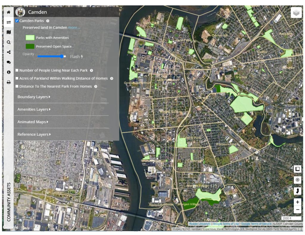
The online mapping tool, known as the Camden Conservation Blueprint, was created by a partnership of New Jersey Conservation Foundation, Rowan University and The Nature Conservancy; and supported by a grant from New Jersey Health Initiatives (NJHI), a statewide grantmaking program of the Robert Wood Johnson Foundation.
“This conservation- and health-focused interactive mapping tool was made especially for Camden,” said Michele S. Byers, executive director of New Jersey Conservation Foundation. “In addition to helping city residents find places to exercise and get fresh foods, the Camden Blueprint has a huge amount of information to guide local organizations that provide facilities and services for the community.”
The map is available at www.njmap2.com/communityassets/camden.
The Camden Conservation Blueprint was developed with the help, direction and input of the community. The map is loaded with more than 80 data sets related to public health and the built environment, including demographics, wellness statistics, places to find healthy food and community services, and detailed information on parks and amenities. It’s simple to use and intended for everyone, from residents to professional planners.
Helping Community Organizations
Local organizations are already finding ways to enhance their work using the Camden Conservation Blueprint.
The New Jersey Tree Foundation, for example, will use the map to plan future tree planting projects and assess the impact trees make in Camden. “We look forward to using the Conservation Blueprint to check local demographics, asthma rates, urban heat island effect, and more,” said Meredith Brown, program coordinator for the NJ Tree Foundation. “We thank New Jersey Conservation Foundation and partners for creating the Conservation Blueprint, and look forward to strategizing where trees are most needed in Camden using this important tool.”
The Hispanic Family Center of Southern New Jersey (HFC) will use the Camden Conservation Blueprint to help clients improve their health. “The Conservation Blueprint empowers the community to access parks to better their health and wellness,” said Nicole Wismer, the organization’s director of program analysis and development.
“HFC clients continually express the desire to improve their family’s health through exercise and spending time outdoors,” said Wismer. However, she added, they sometimes don’t use Camden’s parks and green spaces due to questions about conditions, location, access barriers and safety.
“With the help of the interactive Conservation Blueprint tool and NJ Conservation Foundation, HFC trains individuals to use data to decide which parks meet their family’s needs, concerns, and goals,” said Wismer. “Families navigate the Conservation Blueprint tool to find the closest park with amenities like a community grill, walking trail, splash pad, or shade trees.”
Neighborhood Needs
Data from the Camden Conservation Blueprint can also be used to gain a better understanding of neighborhoods and whether their recreation needs are being met. For example, in neighborhoods with lots of children, are there enough playgrounds and is the equipment safe? In neighborhoods where many households don’t own cars, are there enough parks and green spaces within walking distance?
“We know one approach that community leaders can take to address the deep-rooted issues known to influence health is to make better use of available data and share it with other community stakeholders, partners and residents to guide their decision-making,” said Bob Atkins, PhD, RN, FAAN, director of NJHI. “By leveraging the expertise of a cross-sector coalition of Camden partners, the Camden Conservation Blueprint takes data that might have been previously inaccessible and places it at residents’ and community leaders’ fingertips to help them locate available resources and advocate for policy, systems and environmental change that can improve health for all.”
In order to develop the Camden Conservation Blueprint, NJ Conservation worked in close partnership with Rowan University. “Collaboration was key to the blueprint’s success,” said John Hasse Ph.D. AICP, director of Rowan’s Geospatial Research Lab where the mapping technology was developed and is hosted.
“We adjusted and customized our statewide mapping resources to serve the unique needs of Camden’s urban environment and network of city parks,” Hasse added. “Rowan’s expertise in GIS mapping developed the interface to be intuitive and easy to use for Camden users. NJ Conservation’s experience with community outreach facilitated a broad coalition of stakeholders to provide input and feedback to the project. The result is a mapping tool that can be used for a variety of purposes to serve a broad array of Camden residents.”
How to Use Camden Blueprint
To use the interactive map, go to www.njmap2.com/communityassets/camden. An aerial map of Camden will appear on the screen, with the city’s 20 neighborhoods outlined. A menu on the left can be used to switch on and off dozens of “layers” of information, including:
- Parks and open space – The map’s first option shows the locations of parks and preserved open space lands in the city. Other menu boxes can be clicked to find out the number of people living within walking distance (a quarter-mile) of each park, acres of parkland within walking distance of homes, and distance to the nearest park from various neighborhoods.
- Amenities layers – Clicking on this layer allows users to find parks with the features they’re looking for, such as playgrounds, basketball courts, bike racks, multi-use trails, grills, drinking fountains, water play features and more. The amenities layer also includes information on the conditions of park facilities.
- Reference layers – These layers can be switched on and off to show locations of farmers’ markets, hospitals, urgent care centers, bus stops, train stations, community resource sites like food pantries and soup kitchens, schools and more. Other layers show tree canopy, vacant parcels, industrial sites, known contaminated sites, flood-prone areas and priority lands for conservation. Demographic information is also available, including median age, single headed households with children, and households without a car.
About New Jersey Conservation Foundation
New Jersey Conservation Foundation is a private nonprofit that preserves land and natural resources throughout New Jersey for the benefit of all. Since 1960, New Jersey Conservation has protected 125,000 acres of open space – from the Highlands to the Pine Barrens to the Delaware Bayshore, from farms to forests to urban and suburban parks. For more information about the Foundation’s programs and preserves, go to www.njconservation.org or call 1-888-LAND-SAVE (1-888-526-3728).
New Jersey Conservation began working in the City of Camden in 1986, with the long-term vision of establishing a greenway along the Cooper River. More than 30 years later, the Foundation is playing an active role in the city’s renaissance, working with numerous community partners to provide access to nature and waterways, education programs and recreation opportunities.
About New Jersey Health Initiatives
New Jersey Health Initiatives is a statewide grantmaking program of the Robert Wood Johnson Foundation (RWJF). Established in 1987 in honor of the New Jersey philanthropic legacy of RWJF’s founder, General Robert Wood Johnson II, NJHI supports innovations and drives conversations to build healthier communities through grantmaking across the State of New Jersey. To meet the many health needs of our state’s diverse populations, regions and communities, the NJHI program encourages collaboration across sectors to foster deep relationships committed to long-term change affording all New Jerseyans the opportunity to live the healthiest life possible. Learn more about NJHI at www.njhi.org.
Explore More
The State
We're In